We are exploring more ways to spread information about our activities via the internet and social media. The latest additions are www.rslab.se – The Ljungberg’s Lab’s website. Check this for the latest activities! Remote Sensing – SLU is on Facebook. Like us!
New grants received
New grants were received in 2016! Jörgen Wallerman was the main applicant for a grant from the Swedish Forest Society Foundation, with Erik Willén (Skogforsk), Johan Fransson, and Jonas Bohlin as co-applicants. Approximately 800 tSEK over 2016-2017 will go to the project ”Large scale and accurate mapping of forest data from stereo-matched aerial photos with… Fortsätt läsa New grants received
Remote Sensing and Forest Inventory course given for first time
Spring term 2016 started with a new course called ”Remote Sensing and Forest Inventory”. It’s the first time a 15hp course is given on Remote Sensing and Inventory combined. Eleven forestry undergraduates and two PhD students have taken the course which has run from January 18 – March 21. New elements in the course have… Fortsätt läsa Remote Sensing and Forest Inventory course given for first time
A productive Fall
The Remote Sensing group at SLU has had a very productive Fall. The latest fruits of that labor have been several successful grant applications, including: ”Tree species information from airborne and terrestrial sensors” – 1.8 million SEK from Hildur och Sven Wingquist Foundation for forest science research to Eva Lindberg (main applicant), and Johan Holmgren,… Fortsätt läsa A productive Fall
September activities
The summer vacation is over and remote sensing activities are back in full swing. Among other things, there are several conferences coming up in September that we have or will be attending. These include: Photogrammetric Week in Stuttgart, Germany, where Jonas Bohlin attended. FOSS4G, which Mats Högström is attending. Silvilaser 2015 where Håkan Olsson is a committee… Fortsätt läsa September activities
Formas projects granted which will use remote sensing
The Swedish Research Council Formas has made a decision on the projects awarded money from their call ”Research on forest raw materials and biomass – sustainable primary production”. The application ”Data assimilation for supporting sustainable forestry” where Håkan Olsson was the main applicant (Göran Ståhl, Johan Sonesson, Anton Grafström, Johan Holmgren, Lars Wilhelmsson, & Eva… Fortsätt läsa Formas projects granted which will use remote sensing
Sentinel-2 has gone into orbit
On the morning of June 23 (01.52 GMT) the Sentinel-2a satellite was successfully launched into orbit. You can read about the launch at the following website European Space Agency Sentinel-2 launch and more on Sentinel-2 on Wikipedia Sentinel-2. Photo: ESA–M. Pedoussaut, 2015 (from http://www.esa.int/spaceinimages/Images)
Laser-based forest maps at SkogsElmia and SkogsNolia
Photo by Svante Larsson, Skogsstyrelsen. 4-6 juni och 11-13 juni kunde besökare på SkogsElmia och SkogsNolia titta på sin skog i de rikstäckande skogskartor som SLU och Skogsstyrelsen tagit fram. Kartorna, baserade på Lantmäteriets nationella laserskanning och Riksskogstaxeringens provytor, visar uppskattad volym, höjd, diameter, grundyta och biomassa. Data är fritt tillgängliga på www.skogsstyrelsen.se/skogligagrunddata. Skogsägare kan… Fortsätt läsa Laser-based forest maps at SkogsElmia and SkogsNolia
Göran Persson’s visit to SLU on Feb. 17
On February 17th, Göran Persson (former Swedish Prime Minister and currently Chairman of the Board of Sveaskog) visited SLU to give a talk about the future of the Swedish forest industry and to meet SLU employees and students. Mattias Nyström took the chance to show Göran Persson some recent work from the Remote Sensing section,… Fortsätt läsa Göran Persson’s visit to SLU on Feb. 17
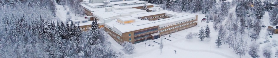
SLU from above
We took these photos during a flight the day before Christmas. The hexacopter we’re using belongs to the educational lab Ljungbergslaboratoriet. The winter is not the best environment for electronics, but it’s better than rain. As you see below, it looks like a snowstorm when the copter takes off from the ground. We haven’t been… Fortsätt läsa SLU from above